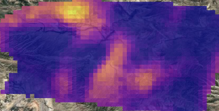
Based on gross gas production, the loss rate (or emissions intensity) of 1.8% to 2.9% observed in the Permian basin in these preliminary measurements is at least nine times higher than the 2030 target loss rate of 0.2% promised under the industry’s public commitments. In Utah’s Uinta basin with its aging, leak-prone infrastructure and low producing mix of oil and gas wells, MethaneSAT observed loss rates around 9%, ten times higher than in the more productive, gas-dominant Appalachian basin.
“This groundbreaking technology empowers oil and gas producers to eliminate methane leaks and to play an important and essential role as part of the solution,” said Sir Andrew Steer, President and CEO of the Bezos Earth Fund. “We are proud to be an active partner in this initiative."
The new snapshots provide a clear sense of the scale of the problem. Total oil and gas methane emissions observed in these images range from roughly 50 tonnes/hour in the Uinta to 280 tonnes/hour in the Permian, and up to 420 tonnes/hour in the South Caspian basin.
“MethaneSAT represents a significant advance in remote sensing technology that offers powerful insights for many kinds of stakeholders,” said Dr. Ritesh Gautam, Lead Scientist for MethaneSAT. “The ability to quantify total methane emissions over wide areas with high precision and high resolution makes it an effective, complementary and globally accessible tool to track changes in emissions in order to meet global methane mitigation goals.”
Emissions directly quantified by MethaneSAT are significantly greater than reported based on bottom-up estimates. Subtracting non-oil and gas sources, methane emissions observed in the Permian are still three- to five times greater than estimates by EPA in their 2020 gridded inventory — in line with the data from an aircraft version of MethaneSAT collected in 2023 — while those observed in the South Caspian are over 10 times higher than reported in the independent global 2022 EDGAR emissions database.
Meanwhile, the Venezuela observation demonstrates the strengths of MethaneSAT in detecting emissions in between clouds across wide regions, due to the satellite’s unique combination of wide swath, high precision and high spatial-resolution measurements. This capability fills a major gap in existing regional data because large portions of the information collected by other satellites is discarded due to even modest cloud cover.
